In this article:
Especially during the holiday season, you can often hear the question in the catchment area of Husum in North Frisia: Where is the Nordstrand here? If you were to ask the three well-known characters from the advert for Germany's northernmost brewery, the answer would probably be as short as it is concise: "It's not here", followed by the characteristic plop of their beer bottles.
The well-behaved North Frisian, on the other hand, kindly explains that although there is no beach far and wide, there is a peninsula just outside Husum called Nordstrand.
The original island of Strand, the western part of which formed today's Pellworm, was partially submerged in a storm surge in the 17th century. What remained was the island of Nordstrand, Pellworm and the Hallig Nordstrandischmoor. In 1935, the 4.3 kilometre long Nordstrand dam was built, permanently connecting Nordstrand to the mainland.
Two spots on Nordstrand for all wind directions
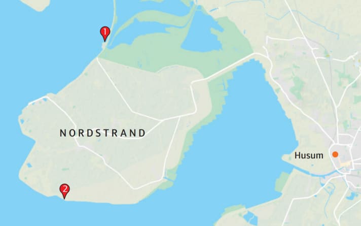
This is where it gets interesting for water sports enthusiasts, as Nordstrand is surrounded by water on three sides. Easy to reach via the A7/A23 motorway, roughly towards Husum, follow the B5 past Husum and follow the signs for Wobbenbüll/Nordstrand at the end of Hattstedt. Once you reach Nordstrander Damm, the vastness of the landscape opens up with the Wadden Sea of Husum Bay to the left and the Beltringharder Koog nature reserve to the right.
The Koog is off-limits and access to the water is not that easy, because like everywhere else on the German North Sea coast, the land here is surrounded by dykes and there are often extensive lahn fields in the mudflats that serve to protect the coast. However, lahns are the enemy of all Finns and the friend of the local board repair shop. This reduces the number of usable offshore spots to two, but they cover all wind directions.
However, nature also has a say here, which is why the tide table is a surfer's best friend, otherwise you are simply left high and dry at low tide.
Area information Nordstrand
General
The history of the Nordstrand peninsula is characterised by the eternal battle between man and nature. In the past, storm surges not only cost the lives of many thousands of people, but also reclaimed land that had been painstakingly wrested from the sea. This is why massive dykes for coastal protection characterise the landscape around Nordstrand today. The offshore Halligen islands are unique and to this day demand a completely unique way of life from their inhabitants that a Binenlander can hardly comprehend.
Journey
From Hamburg, take the A7/A23 motorway towards Husum. At the end of the motorway, continue on the B5 past Husum and turn off towards Wobbenbül/Nordstrand at the end of Hattstedt.
Living
There are many flats and holiday homes on Nordstrand. You can find an overview here: www.nordstrand.de .
There are three campsites or motorhome pitches on the peninsula:
- Camping Nordstrand is located directly behind the dyke and not far from the Holmer Siel spot: www.nordstrand-camping.de
- Just behind the causeway to Nordstrand is the Womoland Nordstrand motorhome car park: www.womoland-nordstrand.com
- The Magaretenruh camping and tent site is located in the Süderhafen district near the water: www.camping-nordstrand.de
Wind, weather and tides
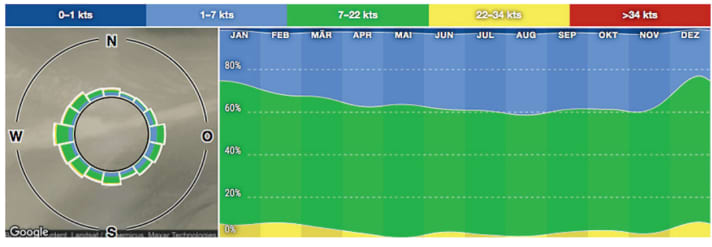
As at most spots in northern Germany, westerly winds predominate and low-pressure areas over the North Sea are usually responsible for fast-moving air. On Nordstrand, however, easterly winds can also become very strong due to thermal amplification. In summer, the average water temperature can reach around 19-20 degrees. On Nordstrand, the tidal calendar must always be observed, as windsurfing is only possible around two and a half to three hours before and after high tide. You can find a detailed tide table on the website of the BSH (Federal Maritime and Hydrographic Agency): www.bsh.de
Windfinder also gives a water level indication for high water under the spot Strucklahnungshörn. The normal level is 3.9 metres.
Shops and schools
There are no surf shops or schools on Nordstrand. The nearest schools are the X-H2O water sports centre in St. Peter-Ording ( www.x-h2o.de ) and Wassersport Büsum ( www.wassersport-buesum.d e). The nearest, smaller shop is Surfers Corner in Bredstedt. At Surf Pirates in Flensburg you can get the full programme ( www.surfpirates.de )
Loc(k)al tip
After the session, you can recharge your batteries in many different ways. Around the "Hotel Halligblick" between Holmer Siel and Strucklahnungshörn harbour on the new climate dyke, there are a number of places to go for all tastes. Enjoying a sundowner in the Halligblick on the dyke with an unobstructed view over the sea is something special, especially as the sun sinks right behind the Hallig in summer. The "Wattn Grill" at Süderhafen harbour is an insider tip for all kinds of burger creations and hearty North Frisian cuisine. The "Engelmühle" and the restaurant at the "Heverstrom" are in the neighbourhood.
There is also plenty to do in the region apart from water sports. Boat trips to the islands and Halligen, carriage rides to the Hallig Südfall or a stroll through the Stormstadt Husum. When it comes to water sports in this region, the experience of nature and the associated deceleration are at the forefront, making it ideal for non-surfing families.
- More info at nordstrand.de
The best windsurfing spots on Nordstrand
1) Holmer Siel
The first spot is on the north side of Nordstrand at Holmer Siel. Coming from the dam, take the Elisabeth-Sophien-Koog junction and after about three kilometres you will automatically reach the car park at the top of the dyke. Straight ahead in the distance you can see the Hallig Nordstrandischmoor. To the right is the small harbour with the sluice, whose protruding stone breakwater gives the whole thing a "bay" character.
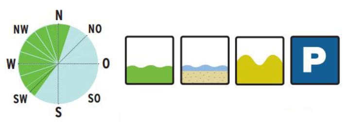
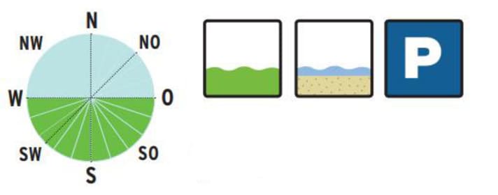
The usable wind directions range from south-west to north-east, whereby the easterly directions can become very gusty in the first 200 metres through the harbour and become offshore due to the coastline. The more easterly the more offshore. On the other hand, the locals rave about the days in summer when the easterly wind can create a thermal jet here, which sometimes creates nuclear winds when the pennants hang down all over the country. The disadvantage of easterly winds at both spots on Nordstrand: after several days in the east, the water is pushed so far out into the North Sea that it doesn't even reach the front of the dyke at high tide.
Easy access via the stairs
There is a staircase or ramp at both spots for easy access. If you orientate yourself at Holmer Siel by these stairs, you will not come into contact with the lahns further to the left. The area to the right of the steps up to the pier is free of obstacles. In a south-westerly direction, you can head straight out and find plenty of ramps for jumping a little further out. A crossing to the Hallig, three kilometres away, is an experience, but you should be aware that the two large tideways of the Holmer and Lüttmoorsiels drain and drain the bay and damage to equipment can mean trouble if the water runs out. It's best to ask the locals. If you want to visit the Hallig, you should only keep directly to the left of the jetty, as there are of course plenty of coastal defences hidden in the water around the Hallig. You can walk from the jetty to Halligkroog (only on the paved paths). Homemade cakes and various dishes invite you to linger, but if you don't keep an eye on the tide table or the wind forecast, your stay may be extended by at least twelve hours.
Other options for visiting the Hallig are a mudflat hike from Lüttmoorsiel or by excursion boat from Strucklahnungshörn harbour. Otherwise, there is also the "Strandkorb" (beach chair) at Holmer Siel, 400 metres down the road, where you can buy cheese, cakes, snacks and a toilet.
2) Trender march
The Trendermarsch spot is located almost exactly at the southern end of Nordstrand. Coming from the dam, head towards Süderhafen harbour, then turn left at the end of the village towards the dyke into the street "An de Wehl". After 4.4 kilometres you will reach the spot at the Trendermarschweg fork.
There is a shower at the water's edge and a toilet 100 metres down the road. The entrance ramp is located exactly between the last two lahns of the dyke line. To the left, there are a number of lanes, usually marked by the locals, leading out about 140 metres at intervals of 150 metres.
The best wind direction here is anything but a "north" in the forecast. The ground is sandier than at Holmer Siel, but wearing shoes can protect you from the occasional mussel contact. Around 2.5 kilometres out is the Heverstrom, which drains and irrigates the entire Husum Bay and therefore creates quite a current. On the one hand, this is a good thing, because it makes for official jump ramps, but on the other hand, it's worth bearing in mind if the power joint is getting a bit long in the tooth...
Both spots are generally also suitable for beginners, as you can stand 150 metres away from the dyke for a long period of time, whereby the water in the Trendermarsch is about belly height at the dyke at its highest level, while at Holmersiel it is about 30 centimetres higher. Here too, it is advisable to take a look at the BSH website (water level report), depending on the phase of the moon, wind strength and direction, the water level can also be significantly higher or lower.
Text: Markus Jatzkowski
