In this article:
In contrast to the Mediterranean, where the coasts are often under the influence of local and predictable wind systems, our Central European spots are dominated by changing air pressure patterns. To stick with the technical jargon, it's the large-scale weather conditions that make the difference between pleasure and frustration on the board.
The change from one weather situation to another is often controlled by the jet stream. This is the zone of strong winds in the upper atmosphere that serves up a steady stream of lows and intermediate highs from westerly directions. And should the jet stream be conspicuous by its absence, the hour of the stable high strikes, bringing calm to the otherwise volatile weather patterns - sometimes without wind, sometimes with a decent gliding breeze, depending on the position of the high-pressure centre.
Experts distinguish between a whole range of major weather conditions. However, with regard to the wind and weather conditions between Knokke, Sylt and Usedom in the north - and Lake Constance and Lake Chiemsee in the far south - only five major weather conditions are important. Let's start with the most important one, which has a major impact on our weather: the westerlies.
The western position
Weather map and high season
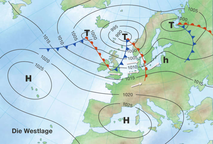
The typical weather map shows low pressure from Iceland to Scandinavia and high pressure from the Azores to the western Mediterranean. Our Central European spots lie in the gusset between the two main players in a westerly air flow. Embedded in the current are Atlantic lows. In between, the atmosphere calms down from time to time when so-called intermediate highs pop in for a day or two.
Westlage - the dominator
Our weather in Germany is often dominated by westerlies. Between the low pressure in the Iceland-Scandinavia region and the high pressure over the Azores and the western Mediterranean, low-pressure troughs repeatedly move across Central Europe, especially in summer.

The westerly situation is the most frequent major weather situation and gives our climate zone its name (westerly wind zone). If we take a closer look at the frequency, the statement does not apply to May, but does apply to the other months of the summer half-year. The peak season is the summer; in July and August, the westerlies are a heavyweight among the major weather conditions with 30 to 33 per cent.
Typical wind and weather conditions with westerly winds
The average wind, usually from the south-west to west-north-west, blows with a force of four to five in westerly directions in the waters of the English Channel and the North Sea. A force four is typical for spots in the Baltic Sea and inland northern Germany. And for the southern German spots usually three to four Beaufort, so there is no gliding wind guarantee here.
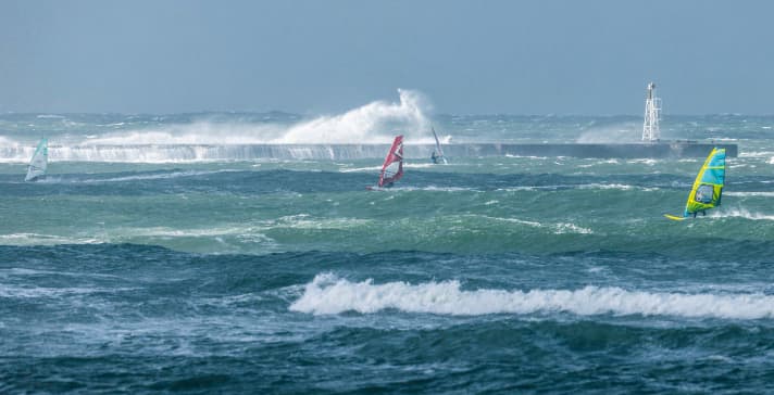
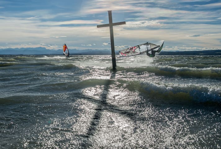
Sometimes it becomes too much of a good thing, as the westerly situation is the general weather situation with the highest potential for strong winds and storms. The North Frisian coast is particularly affected by this among the local areas. It's hard to believe, but in the far south, in the foothills of the Alps, the lakes can turn into extremely challenging areas with a promising five to seven Beaufort when the wind blows in a certain direction, namely west-north-west. This is due to the so-called guard rail effect of the Alps.
One downside of this general weather situation is the changeable weather. Warm air masses alternate with cold ones, and at times we are crossed by Atlantic lows almost non-stop. We then experience a rapid succession of warm front rain, warm sector with clearing, cold front rain and finally the backside weather with its mix of sun, clouds and showers. The changeable weather is interrupted by sunny intermittent highs, but these are more of a flying visit.
As the centre of high pressure shifts from southern Europe to the Alps, the weather improves. The sun often shines, especially on the inland lakes of southern Germany, but the wind yield leaves a lot to be desired. This friendly variant of westerly weather (anticyclonic westerly situation) is ideal for all areas of northern Germany: longer, sunny spells alternate with harmless cloud fields, with rain at most from time to time. The most important thing: there is enough wind for all surfers!
The north-west position
Weather map and high season
The air pressure distribution shows an Azores high that has shifted to the north-east. Its counterpart is located over northern Europe, centred in the northern Baltic Sea-Finland-Baltic region. In contrast to the westerly situation with its alternation between warm and cool, we have to put up with predominantly cool air masses here. The low pressure systems embedded in the north-westerly flow will pass over the Baltic Sea in particular.
The peak frequency of this large-scale weather pattern during the surf season occurs in June and July. Such a north-westerly situation is often responsible for the cold snap (sheep cold) that occurs in mid-June.

Typical wind and weather conditions
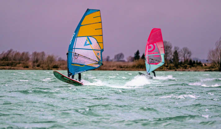
The wind is four to five, gusting to six Beaufort from west-northwest to north-northwest. At the East and North Frisian spots, the wide fetch of the wind across the North Sea often creates challenging surf. Sometimes a so-called lee low develops in the lee of the southern Scandinavian mountains in the Skagerrak-Southern Sweden area. On its southern flank, the wind temporarily freshens up strongly from the beaches of Jutland to the German Baltic Sea coast, sometimes reaching six to eight Beaufort.
Northwest exposure - cold fingers
The weather map shows the shift in the Azores High - and thus the low pressure areas in the north. The weather forecast then often states that cool air of polar origin will reach us. The Baltic Sea in particular then enjoys good winds - which unfortunately makes surfers' fingers freeze.
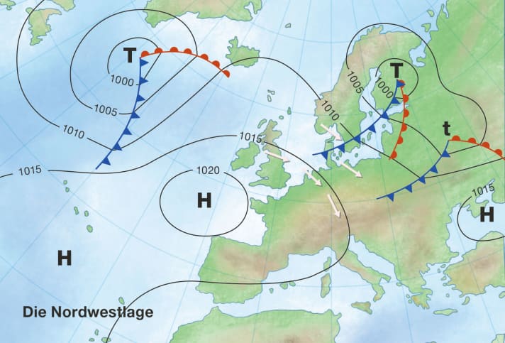

The air is cool everywhere, but the weather varies greatly depending on the region. Thanks to the proximity to the high, the sun is always out on the beaches of the English Channel as far as the Dutch spots. Further east, the weather is changeable, with occasional showers, especially from September onwards. In the event of a strong north-westerly current, however, the German Baltic coast benefits from the Skandenföhn (foehn-like clearing in the lee of the Norwegian mountain range).
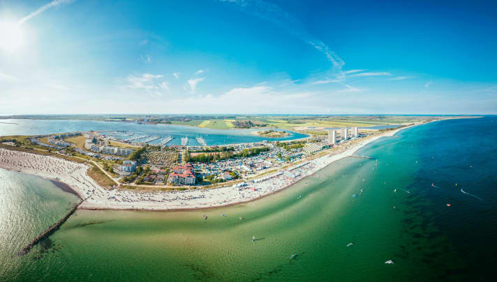
The situation is hardly any different on the lakes in the north and south of Germany, where a mix of sun and clouds and brisk winds can also prevail. The lakes in the foothills of the Alps and directly on the edge of the Alps are an (unfortunate) exception. There, the alpine congestion brings cloudy weather to the spots - with occasional or even repeated downpours. Depending on whether the high pressure influence (anticyclonic north-westerly situation) or the low pressure influence (cyclonic north-westerly situation) dominates. Congestion and rain very often push the wind below the gliding wind limit.

The south-west exposure
Weather map and high season
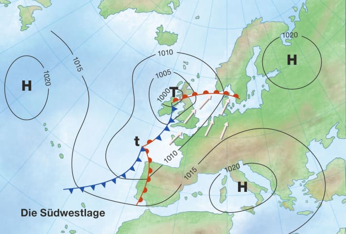
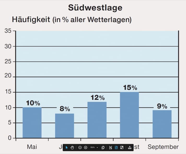
Compared to the north-west situation, highs and lows have swapped places. In the south-west situation, high pressure dominates the Finnish-Baltic-Russian region and the central Mediterranean, while lows dominate western Europe. From the low pressure zone, foothills sometimes cross western Central Europe. This large-scale weather situation has its maximum frequency in August.
Typical wind and weather conditions
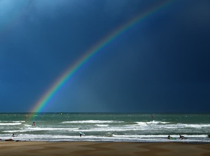
It usually blows at three to five Beaufort. From the beaches of the English Channel to the Frisian spots, it is usually four to five Beaufort, further east and on most inland lakes it tends to be three to four Beaufort. It is often muggy and warm.
The weather, on the other hand, could not be more different. Fronts are moving across the English Channel and the coasts of the North Sea from time to time, bringing showers and sometimes heavy thunderstorms - with strong winds and squalls at times. On the western edge of the Alps, there is the occasional threat of warm thunderstorms. Otherwise, surfers on the beaches of the Baltic Sea, as well as on many inland lakes, often enjoy quite friendly weather.
With a pronounced south-westerly aspect, it's foehn on the edge of the Alps. This means little wind for the Alpine foreland lakes, while the spots directly on the edge of the Alps, such as on the southern shore of Lake Constance or the Kochelsee in Upper Bavaria, experience the foehn quite differently: Here, strong foehn gusts fall from the Alpine valleys onto the spot.
South-west facing - warm and humid
With a south-westerly aspect, it is usually quite warm here, but also humid. Especially in summer, this is the weather situation in which powerful thunderstorms can form, both on the coasts and on the edge of the Alps.
The high pressure situation
Weather map and high season
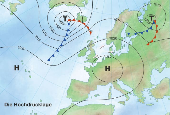
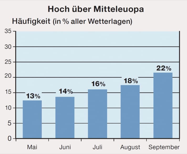
An extensive area of high pressure lies with its centre over the middle of Europe. Sometimes it is also a very elongated high pressure zone over Central Europe that connects a Russian high with an Atlantic high (high pressure bridge). This type of large-scale weather system is most likely to determine the weather at the spot in August and September - with an occasional maximum in the second half of September (Indian summer).
Typical wind and weather conditions
As a glance at the weather map suggests: This is the general weather situation with the greatest potential for lulls. Calm winds are to be expected in the morning and early morning in particular - the ideal weather situation for the late risers among surfers! Otherwise, light winds of one to three Beaufort from varying directions are typical. Only on the North Frisian coast are the winds a little stronger, usually three Beaufort from the west. Sometimes the centre of gravity of the high lies over western Central Europe and extends as far as the southern North Sea. Then surfers can hope for a gliding wind, at least in the areas of the Baltic Sea.
Thermal winds are the last hope for surfers. Unfortunately, the land-sea wind circulation in the North Sea and Baltic Sea in our latitudes is nowhere near as reliable as in the tropics or the Mediterranean. The situation is better in the foothills of the Bavarian Alps. The lakes there benefit from a thermal equalising circulation on the edge of the Alps, which at least provides athletes with winds of force three to four from the east to north-east at midday and in the afternoon.
In contrast to the wind, the weather leaves nothing to be desired: there is plenty of sunshine with warm, even hot temperatures in midsummer. On the inland lakes in September, you sometimes have to wait until late morning for localised patches of fog and high mist to clear. As already mentioned, a good weather situation for late risers.
High pressure situation - calm days
The typical Indian summer weather conditions in September, which no windsurfer associates with usable wind. But sunny weather makes up for the flat days - but don't worry, the autumn storms are already waiting in the wings in September.
All parts of the wind special:
- The west wind
- The east wind on the Baltic Sea
- Ora and Vento on Lake Garda
- The foehn in the Alps
- The Meltemi in Greece
- The bora in Croatia
- The sirocco in the central Mediterranean
- The mistral in the south of France
- The Tramontana in the northern Mediterranean
- The Levante in southern Spain
- The trade wind zone
- The roots of the trade winds
- Core trade wind - In the centre of the trade wind
- Passat run-off zone - The end of the Passat
- Interview: Climate researcher Dr Michael Sachweh - "Chasing storms is my passion"
- Windfinder: How wind forecasts are created, the difference between forecast and super-forecast


